更新记录
1.4.7(2024-09-20) 下载此版本
fix: 修复点击poi点位,导致tap事件失效问题
1.4.6(2024-09-01) 下载此版本
update: 更新readme,添加地区经纬度生成小工具链接
1.4.5(2024-03-08) 下载此版本
fix: 修复top属性类型定于错误导致vue3编译异常情况 ps: 感谢社区成员的提问以及解决方案 https://ask.dcloud.net.cn/question/187245
查看更多平台兼容性
| Vue2 | Vue3 |
|---|---|
| √ | √ |
| App | 快应用 | 微信小程序 | 支付宝小程序 | 百度小程序 | 字节小程序 | QQ小程序 |
|---|---|---|---|---|---|---|
| HBuilderX 3.6.3 | × | √ | × | × | × | × |
| 钉钉小程序 | 快手小程序 | 飞书小程序 | 京东小程序 | 鸿蒙元服务 |
|---|---|---|---|---|
| × | × | × | × | × |
| H5-Safari | Android Browser | 微信浏览器(Android) | QQ浏览器(Android) | Chrome | IE | Edge | Firefox | PC-Safari |
|---|---|---|---|---|---|---|---|---|
| × | × | × | × | × | × | × | × | × |
atl-map 微信小程序高德、腾讯、百度地图
简易好用的微信小程序地图定位,封装腾讯、高德、百度地图 sdk,atl-map 开箱即用。
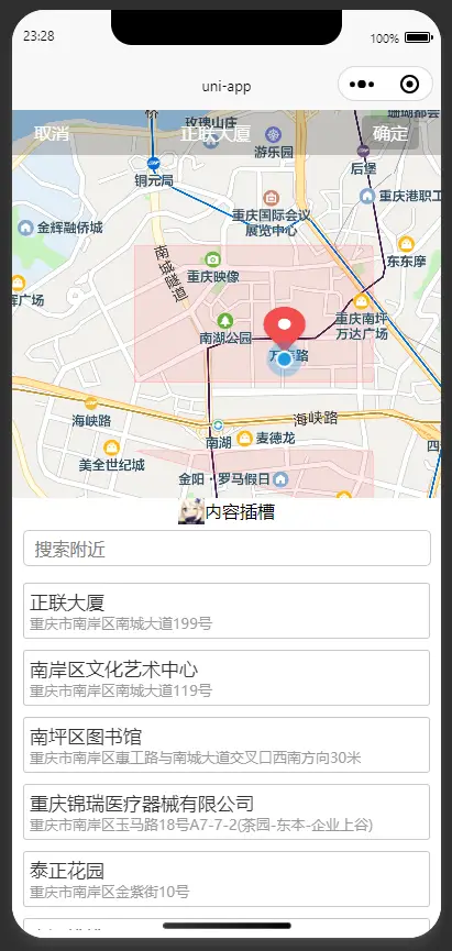
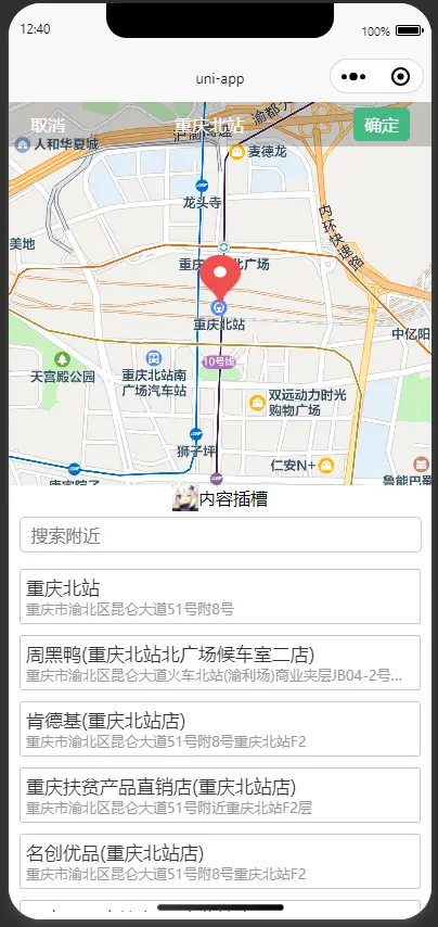
支持点击定位获取具体位置信息和经纬度,地图搜索,经纬度解析(逆地理编码:经纬度->地点描述),新增内容插槽支持自定义内容,电子围栏(地图多边形)
使用前准备
在平台创建应用并申请 key
申请高德、腾讯、百度地图 key
- 高德地图测试 key 申请地址
https://console.amap.com/dev/key/app服务平台选择微信小程序 - 腾讯地图测试 key 申请地址
https://lbs.qq.com/dev/console/application/mine启用产品选择微信小程序 - 百度地图测试 key 申请地址
https://lbs.baidu.com/apiconsole/key/create#/home应用类型选择微信小程序
重要!!!
配置文件 manifest.json 微信小程序需要开启定位权限配置requiredPrivateInfos和permission
"mp-weixin": {
    "appid": "xxxx",
    "usingComponents": true,
    "requiredPrivateInfos": ["getLocation"],//开启定位权限
    "permission": {
        "scope.userLocation": {
            "desc": "开启定位权限"
        }
    }
}
基本使用
vue 模板
<template>
    <view class="">
        <view style="padding: 20px">
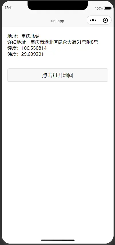
            <view class="">地址:{{ title }}</view>
            <view class="">详细地址:{{ address }}</view>
            <view class="">经度:{{ longitude }}</view>
            <view class="">纬度:{{ latitude }}</view>
        </view>
        <view style="width: 90vw; margin: 5vw">
            <button @click="onClick">点击打开地图</button>
        </view>
        <atl-map :disable="disable" v-if="show" :longitude="longitude" :latitude="latitude" :marker="marker" :mapKey="mapKey" :mapType="mapType" @confirm="confirm">
            <template v-slot:content>
                <view style="position: absolute; bottom: 0; width: 100%; height: 24px; background-color: white">
                    <view style="display: flex; align-items: center; justify-content: center">
                        <image style="width: 24px; height: 24px" :src="imageSrc"></image>
                        <text>内容插槽</text>
                    </view>
                </view>
            </template>
        </atl-map>
    </view>
</template>
js 代码
export default {
    data() {
        return {
            disable: false,
            show: false,
            title: '',
            address: '',
            longitude: '',
            latitude: '',
            imageSrc: '/static/logo.png', //自定义图片
            marker: {
                id: 1,
                height: 50,
                width: 40
                // iconPath: '/static/comm/position.png'
            },
            // mapKey: '42795f9a59358dea58a8bxxx',//高德地图测试key
            mapKey: 'ZNJBZ-E6RHJ-EV3F2-DL73K-ARTTH-3EBRZ', //腾讯地图测试key
            // mapKey: 'p5mGzPEt30bwv1yEkeQGsGP4Xrs9xxxx', //百度地图
            mapType: 'tmap' // tmap bmap amap
        };
    },
    onLoad() {},
    methods: {
        onClick() {
            this.show = true;
        },
        confirm(e) {
            if (e) {
                this.longitude = e.longitude;
                this.latitude = e.latitude;
                this.title = e.title;
                this.address = e.address;
            }
            this.show = false;
        }
    }
};
电子围栏案例
添加了电子围栏demo,因为使用第三方插件判断是否在范围内, 重要!!! 需要在项目中额外下载 @turf/boolean-point-in-polygon 插件 或者是自己写个方法判断是否在范围内
npm i @turf/boolean-point-in-polygon
如果启动报错 @turf/helpers 未找到,那请下载 npm i @turf/helpers
地区经纬度生成 参考 DataV.GeoAtlas地理小工具系列 可以选择范围选择器或者边界生成器生成经纬度数据
vue 模板
<template>
  <view class="">
    <view style="padding:20px">
      <view class="">地址:{{ title }}</view>
      <view class="">详细地址:{{ address }}</view>
      <view class="">经度:{{ longitude }}</view>
      <view class="">纬度:{{ latitude }}</view>
    </view>
    <view style="width: 90vw; margin: 5vw">
      <button @click="onClick">点击打开地图</button>
    </view>
    <atl-map
      :disable="disable"
      v-if="show"
      :longitude="longitude"
      :latitude="latitude"
      :marker="marker"
      :mapKey="mapKey"
      :mapType="mapType"
      @confirm="confirm"
      @changeMarker="changeMarker"
      :polygons="polygons"
      :isPolygons="true"
    >
      <template v-slot:content>
        <view
          style="position: absolute; bottom: 0;width: 100%;height: 24px; background-color: white;"
        >
          <view
            style="display: flex;align-items: center; justify-content: center;"
          >
            <image style="width: 24px; height: 24px;" :src="imageSrc"> </image>
            <text> 内容插槽 </text>
          </view>
        </view>
      </template>
    </atl-map>
  </view>
</template>
js 代码
import booleanPointInPolygon from "@turf/boolean-point-in-polygon";
import { point, polygon } from "@turf/helpers";
export default {
  data() {
    return {
      polygons: [
        {
          points: [
            {
              longitude: "106.57",
              latitude: "29.52",
            },
            {
              longitude: "106.57",
              latitude: "29.53",
            },
            {
              longitude: "106.55",
              latitude: "29.53",
            },
            {
              longitude: "106.55",
              latitude: "29.52",
            },
            {
              longitude: "106.57",
              latitude: "29.52",
            },
          ],
          strokeWidth: 1,
          strokeColor: "#ff000066",
          fillColor: "#ff000016",
        },
        {
          points: [
            {
              longitude: "106.57",
              latitude: "29.51",
            },
            {
              longitude: "106.57",
              latitude: "29.515",
            },
            {
              longitude: "106.55",
              latitude: "29.515",
            },
            {
              longitude: "106.57",
              latitude: "29.51",
            },
          ],
          strokeWidth: 1,
          strokeColor: "#ff000066",
          fillColor: "#ff000016",
        },
      ],
      disable: false,
      show: false,
      title: "",
      address: "",
      longitude: "",
      latitude: "",
      imageSrc: "/static/logo.png", //自定义图片
      marker: {
        id: 1,
        height: 50,
        width: 40,
        // iconPath: '/static/comm/position.png'
      },
      // mapKey: '42795f9a59358dea58a8bxxx',//高德地图测试key
      mapKey: "ZNJBZ-E6RHJ-EV3F2-DL73K-ARTTH-3EBRZ", //腾讯地图测试key
      // mapKey: 'p5mGzPEt30bwv1yEkeQGsGP4Xrs9xxxx', //百度地图
      mapType: "tmap", // tmap bmap amap
    };
  },
  onLoad() {},
  methods: {
    changeMarker(e) {
      const { latitude, longitude } = e;
      const _polygons = this.polygons.map((polygon) => {
        return polygon.points.map((i) => [
          Number(i.longitude),
          Number(i.latitude),
        ]);
      });
      const _point = point([longitude, latitude]);
      const _polygon = polygon(_polygons);
      // 根据电子围栏判断否禁用
      this.disable = booleanPointInPolygon(_point, _polygon);
    },
    onClick() {
      this.show = true;
    },
    confirm(e) {
      if (e) {
        this.longitude = e.longitude;
        this.latitude = e.latitude;
        this.title = e.title;
        this.address = e.address;
      }
      this.show = false;
    },
  },
};
预览


API
Props
| 参数 | 说明 | 类型 | 默认值 |
|---|---|---|---|
| mapKey | 必填,地图 KEY |
String |
腾讯测试 key(每日限量) |
| mapType | 非必填,地图类型(腾讯:'tmap',高德:'amap',百度:'bmap') |
String |
tmap |
| longitude | 非必填,经度 |
String |
当前定位 |
| latitude | 非必填,纬度 |
String |
当前定位 |
| marker | 非必填,点位配置,只支持一个点位 |
Object |
uniapp map 组件默认值 |
| disable | 非必填,确定按钮是否禁用 |
Boolean |
false |
| isPolygons | 非必填,是否显示多边形(电子围栏) |
Boolean |
false |
| polygons | 非必填,多边形配置(具体配置请看案例或者官网说明) |
Array |
[],uniapp map 组件 polygons 配置说明 |
| isCustomBar | 非必填,是否自定义顶部(一般自定义顶部标题栏时使用) |
Boolean |
false (自定义顶部标题栏时留出胶囊按钮安全距离) |
| top | 非必填,地图距离顶部位置(一般自定义顶部标题栏时使用) |
String、Number |
原生标题栏时,默认值:0,"navigationStyle": "custom"为自定义标题栏时,默认值:30 |
| changeMarker | 非必填,点位变化事件(可以通过 turf 插件判断是否在电子围栏内,再配合 disable 属性使用,具体使用参考完整 demo) |
Function |
返回值{title,latitude,longitude,address,...高德/腾讯/百度地图其他参数} |
| confirm | 非必填,点击确定事件 |
Function |
返回值{title,latitude,longitude,address,...高德/腾讯/百度地图其他参数} |
Solt
| 名称 | 说明 | 其他 |
|---|---|---|
| content | 自定义 content 内容 | 使用的是 uniapp cover-view 组件小程序注意事项请看官网 |
注意事项
- 腾讯地图 key 每日限量测试,请自行申请
- 目前只支持微信小程序,其他平台请下载源码自行测试修改github 地址
- 本项目使用 vue2 语法,vue3 也支持
- 微信小程序可能需要设置服务器域名,登录小程序平台 服务器域名 -> request 合法域名(填入用到的平台域名
https://api.map.baidu.com;https://apis.map.qq.com;https://restapi.amap.com; - 百度地图如果遇到接口返回
APP Referer校验失败,在百度地图控制台 删除当前应用,重新创建应用并在 APP ID 填*参考链接 - 如果点击地图没有查出数据,请查看微信开发者工具控制台网络(Network),是否有查询接口返回
{"status":200,"message":"APP不存在,AK有误请检查再重试"}、{"status":"0","info":"INVALID_USER_KEY","infocode":"10001"}、{"status": 311, "message": "key格式错误"}等类似响应数据,多数是地图 key 的问题,更多状态码查看对应地图平台状态码说明文档 - 完整示例项目使用到了电子围栏,booleanPointInPolygon 等方法使用到了第三方插件,所以下载完整示例项目之后需要
npm i安装相应依赖,只下载插件非完整示例项目可以忽略
优化
开发初衷是为了能够支持各平台地图,满足需要不同地图的开发者,但是这会产生其他问题。一个项目一般情况下只用一个平台,没有用到的组件和 SDK 导致代码冗余,占用内存
所以在设计的时候就将<atl-map />组件设计为一个入口组件,<amap />、<tmap />、<bmap/>为独立的子组件,可插拔。简而言之就是每个子组件可以单独使用,删除不用的组件可以减少体积。
推荐选定自己使用的平台之后,删除其他不用的组件和 SDK。
比如:只用腾讯地图,删除其他地图组件,在uni_modules/atl-map/components 下,删除 bmap、amap 文件夹,修改入口文件atl-map.vue,只用tmap组件
<template>
  <view>
    <tmap
      v-else
      :disable="disable"
      :longitude="longitude"
      :latitude="latitude"
      :mapKey="mapKey"
      :marker="marker"
      @confirm="confirm"
      @changeMarker="changeMarker"
      :polygons="polygons"
      :isPolygons="isPolygons"
    >
      <template v-slot:content>
        <slot name="content"></slot>
      </template>
    </tmap>
  </view>
</template>
js 只引入和注册tmap组件
<script>
import tmap from '../tmap/tmap.vue';

    ...
    components: {
        tmap,
    },
    ...
<script />
这样就减少冗余代码,节省内存


 收藏人数:
收藏人数:
 https://github.com/13982720426/uniapp-plugin-atl-map.git
 下载插件并导入HBuilderX
 下载示例项目ZIP
 赞赏(20)


 下载 2018
 赞赏 20
赞赏 20

 下载 9692520
 赞赏 1528


 赞赏
赞赏
 京公网安备:11010802035340号